A storm overnight has left a swath of roads in the northern half of the state partly to mostly covered and slick according to the Department of Transportation.

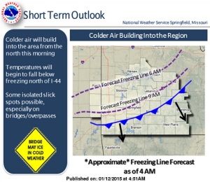
This weather graphic from the National Weather Service estimates the location of the “freezing line” through 9am in southwest Missouri.
As the “freeze line” continues to push farther south this morning, National Weather Service meteorologist Jim Sieveking says roads in more areas of the state could start to become slick where they aren’t already.
“We’ve got a lot of moisture that’s still on the roads and the temperatures are going to be falling pretty drastically this morning,” Sieveking told Missourinet. “In Columbia right now it’s 32 degrees but you don’t have to far up in Kirksville and it’s already down to 17. That cold air is filtering south and as that happens some of the roads that are untreated or don’t have any salt on them could freeze up and cause some hazardous conditions.”
Elevated surfaces such as bridges are typically the first to freeze.
As temperatures fall in parts of the state where roads haven’t already been slick today, Sieveking says some drivers could be caught by surprise.
“It might look just wet or maybe even experience that it’s just wet but then you hit an icy spot and it could be some hazardous driving conditions there,” he said. “We’re just trying to keep people alert of the changing conditions as the temperature plummets into the 20s and the teens this afternoon.”
The Highway Patrol is so far attributing about a dozen accidents last evening and overnight to slick road conditions.
See Missouri road conditions with the Transportation Department’s Traveler Information Map, which is also available as an app on Apple or Android.


