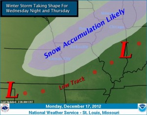
The National Weather Service says a “very powerful” winter storm could bring some significant snowfall to northern Missouri, Wednesday night and Thursday morning.

The National Weather Service is forecasting a major winter storm in the Midwest later this week. (Image courtesy, National Weather Service)
Meteorologist Matthew Dukes says the storm will develop beginning tonight over the west coast.
“The best chance for wintry weather in this part of the country looks to align itself from the Kirksville area off to the southwest near Kansas City.”
Accumulations are difficult to predict at this point, but Dukes says several inches of snow is possible in Missouri by the time it quits falling Thursday morning.
The system will reach across the entire Midwest.
Dukes says it will produce, “thunderstorm activity across the Southern Plains and toward the Gulf of Mexico with very heavy and widespread heavy snow expected across portions of Nebraska, Iowa, Minnesota and Wisconsin where the latest estimates could be as much as 5 inches, maybe even up to a foot of snow in some locations and areas north of Missouri.”
The Weather Service says the forecast could change between now and Wednesday, so Missourians are encouraged to keep an eye on it.
“The snowfall forecast could change in some regards especially as we move into northern Missouri and this could have some impacts as well into Central Missouri if things do trend a certain way.”

