May 2012, the eighth dryest May on record in Missouri, is being followed by what will likely be a June in the top 10 for dryness as well. University of Missouri climatologist Pat Guinan says if you want this drought to end, that’s not a good omen.

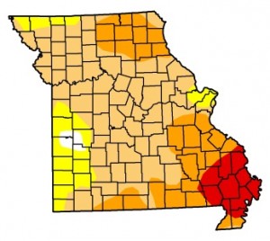
The latest U.S. Drought Monitor map for Missouri (click link to go to U.S. Drought Monitor website).
Guinan says May and June usually make up the wettest two-month period in a year in Missouri, with around 10 inches of rain. So far the two months have seen only about 4 inches. That’s drawing comparisons to 1988, when began a drought that lasted two years.
“That was a historic drought that impacted much of the central and western part of the country,” he tells Missourinet. “In fact, when you look at the economic damage that was due to the 1988 drought you have to go all the way back to the dust bowl years of the 1930s.”
Guinan says triple digit numbers are also unusual in the month of June another fact he says compares to 1988.
There is no sign that the hot, dry pattern is going to lift.
“The latest (outlook) for the month of July is not encouraging,” he says. “They are indicating above normal temperatures and below normal precipitation across all of Missouri.”
The latest U.S. Drought Monitor information has 13 counties in southeast Missouri all or partly in extreme drought.

